Kugluktuk / Coppermine River
Designation
The 450 km Coppermine, in the western part of Nunavut, was nominated to the Canadian Heritage Rivers System in 2002 for its natural heritage, cultural heritage, and recreational values.
The river has long been a travel corridor for the indigenous peoples of the North. Copper deposits found along the river were important to the first peoples who lived there. To this day, the river continues to support the Inuit lifestyle and culture.
The river flows through lands rich in wildlife, where muskox and caribou graze on the sparse vegetation of the uplands, and wolves and grizzlies patrol the river banks in search of food.
Cultural Heritage
The Coppermine is the ancestral home of Inuit and Dene peoples, and ancient campsites can be found along the entire waterway. For thousands of years the Coppermine River has been a well-used travel route, favoured for its resource rich environment. The Pre-Dorset people hunted along its banks using tiny tools chipped out of flint or chert, including small knife blades, arrowheads and scrapers.
Today, ancient campsites are common along the river, and paddlers will find past and present food storage cache sites, fox traps, kayak racks, hunting blinds (called ‘taluit’) as well as game funneling systems of stone cairns (called ‘inuksuit’). These archaeological features are wondrous to see in person, but should be respected and left undisturbed. The Department of Culture and Heritage for Government of Nunavut encourages anyone who comes upon archaeological features, sites or artefacts to report the findings to the Territorial Chief Archaeologist.
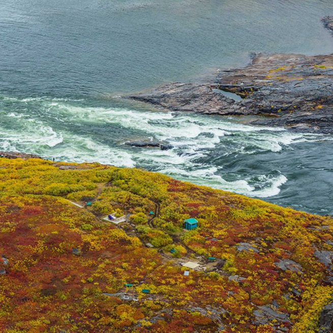
Near the mouth of the river, Kugluk (Bloody Falls) Territorial Park features a narrow gorge, waterfall, and rushing rapids. The fascinating history of this site includes its millennia-long use as a fishing camp. The Coppermine also figured prominently in the exploration of the arctic, and featured in the voyages of Samuel Hearne in 1771, in the first Franklin expedition, in 1820, and the second Franklin expedition, in 1825.
Natural Heritage
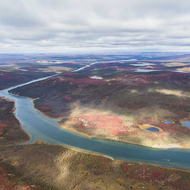
The Coppermine River is 450 km long (including the Kendall River and Melville Creek tributaries), and stretches from the Nunavut/Northwest Territories border to Kugluktuk. The watershed river is bordered by Great Bear Lake to the west, Great Slave Lake to the south drains into the and Coronation Gulf to the north.
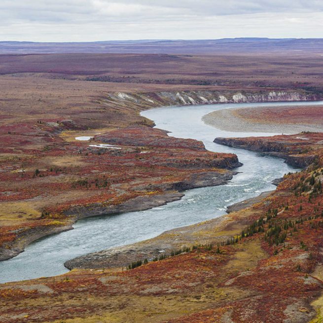
The Coppermine flows energetically through the tundra, where stunted spruce trees dot its banks. Red sandstone cliffs upriver change to white sandstone then into rolling white marine sediments as the river approaches the coast. Chains of small hills dominate a landscape that is rich with wildlife as the river continues its path northward into a more wetland like tundra environment. Muskoxen and caribou graze on the vegetation of the uplands on constant alert for wolves or grizzlies.
The Coppermine provides habitat for arctic foxes, tundra wolves and wolverines that find shelter on the river banks and hunt along the river’s floodplain. The river is also an important habitat for bird species such as tundra swan, geese, and for raptors including peregrine and gyrfalcons. Both golden and bald eagles nest on cliff ledges above the river.
Recreational Heritage
The Coppermine is perfect for both advanced and novice paddlers, who will cross the Arctic Circle on the river’s way to the Arctic Ocean. A number of commercial operators offer canoe, raft and kayak trips on the Coppermine ranging from one to three weeks. River trips usually start with a chartered floatplane out of Yellowknife, in the Northwest Territories, and end at the river’s mouth, in the community of Kugluktuk, Nunavut, where paddlers can camp on the shore of the Arctic Ocean before flying out on commercial flights.
The river has excellent fishing, for various species of fish such as lake trout, arctic grayling and, in the lower reaches of the river, for arctic char.
Facilities

Sed ut perspiciatis unde omnis iste
natus error sit voluptatem
accusantium doloremque
Sed ut perspiciatis unde omnis iste
natus error sit voluptatem
accusantium doloremque
Sed ut perspiciatis unde omnis iste
natus error sit voluptatem
accusantium doloremque
Sed ut perspiciatis unde omnis iste
natus error sit voluptatem
accusantium doloremque
Tips
Nunavut’s parks and special places offer unforgettable experiences; but travel to any remote area can involve risk. Visitors are urged to familiarize themselves with these risks before their trip, and to prepare themselves accordingly. The arctic environment is vulnerable to human disturbance and recovers very slowly. Minimize your impact on park environments, follow park regulations, and try to leave no trace.
Travel within Nunavut’s Territorial Parks offers some of the most breathtaking scenery and magnificent wildlife imaginable, but also involves the risks associate with travelling in any remote area. Travellers are urged to take responsibility for their own safety. Careful preparation and research to learn about local landscapes, weather, wildlife, and potential hazards is advised. Physical conditions within parks, in the water and on trails can change rapidly; weather conditions can shift; and encounters with wildlife are frequent.
The World Commission on Environment and Development defines “sustainable” travel as “meeting the needs of the present without compromising the ability of future generations to meet their own needs.” The World Tourism Organization specifies that sustainable travel is the “management of all resources in such a way that economic, social, and aesthetic needs can be fulfilled while maintaining cultural integrity, essential ecological processes, biological diversity, and life support systems.”
Vital, timely information assistance for safe and sustainable travel in our parks is available through regulations and information posted in our parks; on Government of Nunavut websites and other resources in our park communities; from local guides, hunters and other community residents; and from a wide variety of other print and online resources. Visitors are urged to consult these sources in order to guarantee themselves a safe and memorable experience, and to protect Nunavut’s unique natural and cultural legacy.
.The arctic environment is vulnerable to human disturbance and recovers very slowly. Minimize your impact on park environments. Visitors are required to follow park regulations and encouraged to leave no trace.
Enjoy the park and respect the land. Reduce your impact by following park rules:
- Inuit rights to harvest, fish and camp in the park are protected by law. Do not interfere with Inuit traditional uses of the park.
All-terrain vehicles damage the land. Drive only on designated trails and use the parking areas in the park. - Fishing licenses are required for non-Inuit. Purchase your license at the Wildlife Conservation Office, the Department of Environment or Fisheries and Oceans Canada, most sport fishing lodges, sporting goods, hardware and convenience stores, or at certain offices of the Royal Canadian Mounted Police.
- Respect wildlife and the environment. Do not approach wildlife for any reason. Leave rocks, plants, and other natural objects as you find them.
You are in bear country. Be prepared for bear encounters. Stay alert, travel in groups and with a guide. Keep your campsite and picnic area clean at all times. Report bear sightings to the local Wildlife Conservation Office and Nunavut Parks staff.
Camp a reasonable distance away from day-use areas to allow other park visitors access to these facilities. - Respect other park users. Keep noise to a minimum.
- Keep pets on leash and pick up all pet waste.
- Dispose of garbage in bins or take it out with you.
- Use the outhouses in the park, or in parks with no outhouses, bury human waste.
- Archaeological sites are protected by law. Please don’t touch archeological sites or artefacts. Report archaeological finds to the Territorial Park office.
Nunavut is bear country. To ensure your visit is safe and enjoyable, stay alert to your surroundings, prepare for an encounter and report bear sightings or incidents to the local Wildlife Conservation Office and Nunavut Parks staff.
Bears can be encountered in Nunavut parks. Polar bears may be encountered in any location but are most common in coastal regions. Barren ground Grizzly bears may be encountered in mainland Nunavut. If you intend to travel in Nunavut parks you can reduce your risk of a bear encounter with a few precautions:
- Educate yourself about the area you plan to hike in.
- Hire a local guide with knowledge of how to handle a bear situation.
- Pre-plan, rehearse and know what to do for different bear encounter scenarios.
- Know where bears can be found at different times of the year. Avoid those areas or be especially cautious when traveling through them.
- Be alert and aware of your surroundings. In open terrain, use binoculars to look ahead for bears. If you notice a bear at a distance, take action to avoid surprising it.
- Travel in daylight and avoid areas of restricted visibility.
- Watch for bear signs such as tracks, droppings, daybeds, dens or seal carcasses.
- Never approach a fresh kill. A bear may be nearby.
- Carry food in airtight or bear-proof containers and avoid carrying foods or articles with strong smells. Take all garbage to camp and dispose of it properly. A trail of litter may lead a bear to you or your camp.
- Consider bear deterrents such as noisemakers or pepper spray.
- Report bear sightings or incidents to the local Wildlife Conservation Office and Nunavut Parks staff.
Nunavut Parks published “Polar Bear Safety in Nunavut Territorial Parks”, in March 2007 and produced the video “Polar Bears: A Guide to Safety”, a 27-minute video produced in partnership with Parks Canada. The video contains important information on how people can reduce their chance of encountering a polar bear, and how to best respond if they do meet a bear.
.Inuit rights to enjoy parks and engage in traditional activities are protected by Nunavut Agreement (NA) and the Umbrella Inuit Impact Benefits Agreement for Territorial Parks in the Nunavut Settlement Region (IIBA). The NA and IIBA protect the rights of Inuit to access territorial parks for harvesting. Park visitors are required to respect these rights, and to take appropriate steps to avoid interfering or disturbing Inuit traditional activities.
Inuit rights within a Territorial Park are protected by the Nunavut Agreement (NA) and the Umbrella Inuit Impact Benefits Agreement for Territorial Parks in the Nunavut Settlement Region (IIBA). The NA and IIBA protect the rights of Inuit to continued land use for harvesting, outpost camps, carving stone, access, and other purposes in territorial parks.
Inuit harvesting activities (hunting, fishing and gathering) are allowed in established territorial parks, and will continue to be allowed in areas where a new territorial park may be established in the future.
The NA and IIBA both require that Inuit and the GN jointly plan and manage the lands, waters, and resources within parks. Joint planning and management is the process by which government, Inuit and communities work together to make and implement decisions. The IIBA formalizes joint planning and management by setting out principles and objectives to ensure meaningful Inuit participation in park planning and management decision-making, at both the territorial and community levels. A Nunavut Joint Planning and Management Committee (NJPMC) advises on Nunavut-wide parks initiatives (IIBA Article 13.1.1 d), and Community Joint Planning and Management Committees (CJPMC), working at the community level, plan and manage parks in or near each affected community (IIBA Article 13.1.1 d).
The planning and management process followed by Nunavut Parks will ensure that Inuit Qaujimajatuqangit (IQ) substantially informs the decision-making process, and that visitor uses of a park, and park programs or development, do not conflict with Inuit use and enjoyment of territorial parks.
.All archaeological sites in Nunavut are protected under the Nunavut Archaeological and Paleontological Sites Regulations, which prohibit unauthorized disturbance. Do not move or remove stones, bones, or artifacts, and report new archaeological finds to the Government of Nunavut.
The protection of Nunavut’s archaeological and paleontological heritage is an important priority of the Government of Nunavut (GN), and a responsibility shared with the Government of Canada. Under the Nunavut Act, regulations for the protection, care and preservation of archaeological and paleontological sites are regulated under the authority of the GN Minister for Culture and Heritage (C&H); and study, access, documenting and investigating archaeological and/or paleontological sites and databases require research permits. The GN Department of C&H requires a Nunavut Archaeological Sites Database license to view previously recorded data; and Archaeology and Palaeontology Permits (Class 1 or Class 2) for research projects and inventory fieldwork.
Class 1 permits authorize only the documentation of an archaeological and/or paleontological site, including preparing a site map, recording the site’s geographic location, and the number, type and distribution of features present. Class 1 permits do not allow for the collection of artifacts.
Class 2 permit authorizes the documentation of an archaeological and/or paleontological site along with the excavation and removal of artifacts and/or specimens. These permits are only issued to professionally qualified archaeologists and/or palaeontologists.
Additional information can be found in the C&H department’s Guidelines for Applicants and Holders of Nunavut Territory Archaeology and Palaeontology Permits.
The Department of C&H also administers the Human Remains Policy to ensure that any archaeological investigation or analysis of human remains or associated grave goods will be conducted in a manner that is sensitive to Nunavummiut values, ethical and scientific principles, and which complies with all applicable laws, codes of conduct, and conventions.
If archaeological and/or paleontological sites or artefacts are found in a territorial park, the regulations are not to touch, do not move or remove stones, bones, or artifacts, and immediately report finds to the GN.
The process for all artifact discoveries is quite straightforward; finds have to be reported to the Territorial Archaeology Office, including as much details as possible, for example:
- Name of the person(s) who found the artifacts
- Date of the find
- Location of the find (GPS coordinates) if available.
- Photographs if available
- Any other relevant information
The C&H Department will then address the issue and provide recommendations/action. The Inuit Heritage Trust has three general information booklets on archaeology in Nunavut that are available online (http://www.ihti.ca/eng/iht-proj-guide-booklets.html):
- Booklet for Northern Communities;
- Booklet for Northern Heritage Workers;
- Booklet for Northern Students.
Parks offer a deep emotional connection to the land. They are places that say “katjaqnaaq” – I am content in this beautiful and special place, I have found peace, I am home.
To understand our parks, we must experience them. We must listen to the land.
Nunavut, “our land”, is defined by its people and places. It is an arctic territory that evokes images of vast space and endless skies, wide tundra plains, ice-capped mountains, lands and seas teeming with wildlife, and rich cultural traditions still practiced today.
“Katjaqnaaq”, as much a feeling as an expression, reveals a depth of emotion and connection to a place of incredible beauty and significance. Uttered as a sigh, it can mean “ah – I am happy here, I am part of something.” As a joyful exclamation, it can mean “oh, what a beautiful place!” However it is used, it evokes connectedness to one’s surroundings and a sense of peace and meaning.
The Parks & Special Places division of the Government of Nunavut is working with Nunavummiut to identify and protect these significant areas as territorial parks and special places, understanding that they mean many things to many people: they are places of escape, places for reflection, places of power, and places that celebrate our cultural and natural heritage.
In the North, the idea of a park or special place is different. It is linked more to utility and being on the land than beauty and aesthetics, which are appreciated in a different way. In Nunavut, special places are prime hunting or fishing spots, good camping sites, places where groups of people gathered in the past, or places of mystical significance.
.- Sed ut perspiciatis unde omnis iste natus error sit voluptatem accusantium doloremque
Did you know?
The Inuit of Kugluktuk speak Inuinnaqtun – a slightly different language from Inuktitut – because they are Copper Inuit people, descendants of the ancient Thule people, who have distinct cultural traditions.The Copper Inuit were so named because they made arrowheads, spearheads, ulu blades, chisels, harpoons and knives from copper that was sourced along the shores of the Coppermine River.
Safety Information
- ">
- ">
- ">